Weekend Outlook: January 9-12, 2026

A pair of storm systems will impact our weather over the next few days, but mostly with rain, not snow.

It’s been fairly dry so far this winter, so we’re still experiencing drought conditions across much of the region. Image provided by the National Drought Mitigation Center.

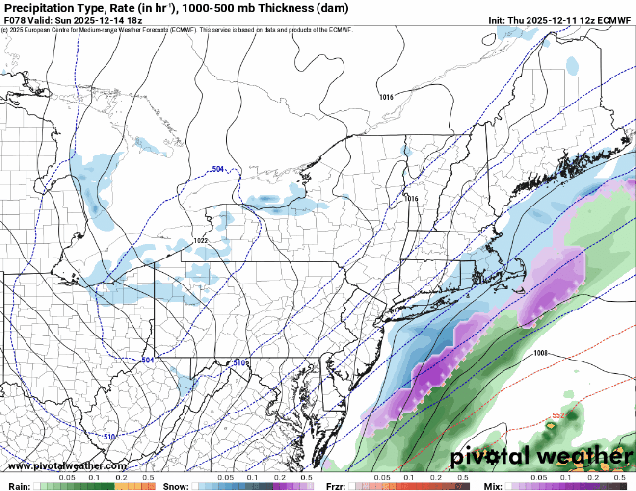
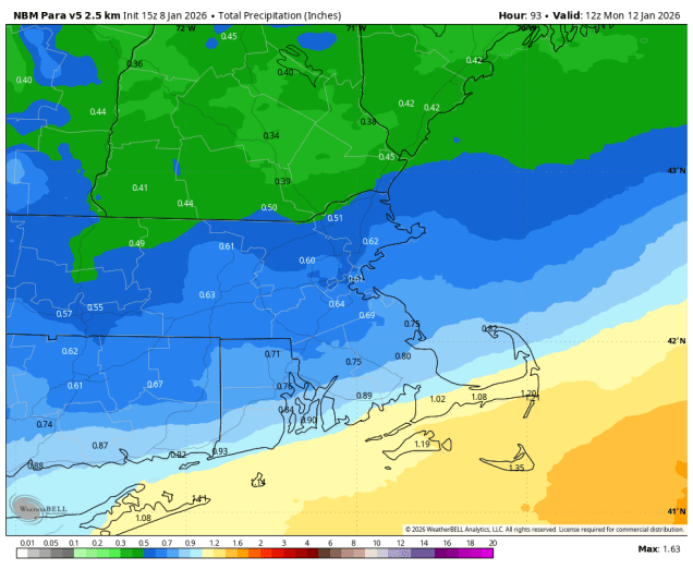
High pressure will slide off to the east tonight, with winds shifting into the southwest, bringing some milder air in. Friday will be relatively mild (by January standards), but clouds will be streaming in ahead of a low pressure system headed for the Great Lakes. As that system moves into Quebec some showers are likely ahead of it Friday evening before a cold front moves through overnight. That front will stall out south of New England allowing some cooler air to move back in. Meanwhile, another low pressure system will head towards the Great Lakes, trying to bring that front back northward as a warm front. As that system moves into Ontario, a secondary low pressure system will develop off the Mid-Atlantic coastline., preventing that warm front from moving in, and giving the new low pressure area a path eastward. This will bring more substantial and widespread rain in for late Saturday into Sunday morning. However, with the cold air in place, precipitation may start as some sleet or freezing rain well north and west of Boston, mainly interior southern New Hampshire and northern Worcester County, as the rain moves in later Saturday. A few additional rain or snow showers in the afternoon as an upper-level low pressure area crosses the Northeast, then high pressure builds in for Monday with cooler and drier conditions. For the Patriots game Sunday evening, it should be mostly cloudy at kickoff, winds out of the northwest at 5-10 mph, with a game time temperature around 37, dropping into the lower 30s by the end of the game.

Much of the area could receive between half an inch and one inch of rainfall this weekend. Image provided by WeatherBell.

Thursday night: Becoming partly to mostly cloudy. Low 22-29.

Friday: More clouds than sun, becoming breezy in the afternoon, showers possible towards evening. High 41-48.

Friday night: Cloudy with showers likely, mainly before midnight. Temperatures continue to rise until midnight, then drop to 33-40 by daybreak.

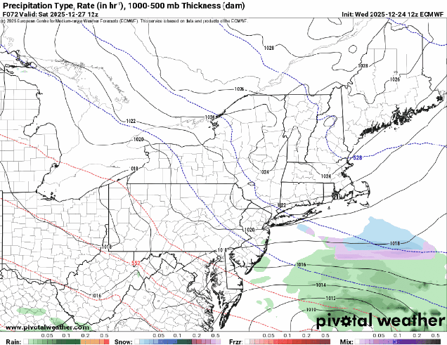
Saturday: Mostly cloudy with rain developing from southwest to northeast, possibly starting as some sleet or freezing rain well north and west of Boston. High 40-47.

Saturday night: Any mixed precipitation changes to all well rain north and west of Boston, periods of rain elsewhere. Low 33-40.

Sunday: Rain ends by midday, mostly cloudy with a few more rain or snow showers possible late in the day. High 38-45.

Sunday night: Gradual clearing, breezy. Low 23-30.

Monday: Partly to mostly sunny, breezy. High 32-39.

Weekly Outlook: January 5-11, 2026

Warmer weather is on the way, but first we’ll have to deal with some wintry weather.

A little snow is expected later today and tonight. Image provided by WeatherBell.

The week starts off on a chilly note, but a weak low pressure system heading our way will bring in some light snow this evening and overnight. Accumulations of a coating to 2″ are likely north of the Mass Pike, with less than 1″ south. The system moves offshore, but another one quickly follows by late Tuesday. Warmer air will be moving in aloft, which may result in some freezing rain developing Tuesday night north and west of Boston, with just rain showers elsewhere. The warmer air may take its time to move inland at the surface, so freezing rain may continue into the morning hours, before everything winds down towards early afternoon. High pressure briefly builds in for Thursday with milder conditions, then another system heads our way for the end of the week. This one should be just rain for most of the region, starting Friday afternoon, but probably not ending until a cold front moves through Saturday evening. It probably won’t be raining the entire time from Friday afternoon through Saturday evening, but there probably won’t be extended dry periods either. High pressure returns with colder weather for Sunday. An early look at the weather for kickoff of the Pats/Chargers playoff game Sunday evening shows dry weather with breezy conditions, temperatures in the middle to upper 30s, and wind chills in the upper 20s to lower 30s.

50s on Friday? It’s possible. Image provided by Weathermodels.com

Monday: Some morning sun, then becoming cloudy with light snow developing late in the day. High 22-29.

Monday night: Mostly cloudy with light snow ending. Up to 2″ expected north of the Mass Pike, 1″ or less to the south. Low 17-24.

Tuesday: Partly to mostly cloudy, some rain possible by evening, freezing rain north and west of Boston. High 31-38, a little milder near the South Coast and Cape Cod.

Tuesday night: Freezing rain likely north and west of Boston, rain showers elsewhere. Low 27-34 during the evening, temperatures hold steady or rise a little overnight.

Wednesday: Freezing rain changing to rain showers before ending north and west, rain showers elsewhere ending in the afternoon. Some late-day clearing possible. High 38-45, a little warmer near the South Coast and Cape Cod.

Wednesday night: Becoming partly cloudy to clear. Low 26-33.

Thursday: Mostly sunny. High 39-46.

Thursday night: Increasing clouds. Low 25-32.

Friday: Mostly cloudy with showers developing. High 43-50.

Saturday: Cloudy with occasional showers, ending at night. High 44-51.

Sunday: A mix of sun and clouds, breezy. High 39-46.

Weekly Outlook: December 29, 2025 – January 4, 2026

As the year comes to an end, our cold weather will not follow suit.

Temperatures will be below to well below normal for much of this week. Image provided by weathermodels.com.

The week starts off with a potent low pressure system moving into southeastern Canada dragging a warm front across the region. In the cold air north of the front some freezing rain is likely this morning, mainly in southern New Hampshire, before the warmer air makes its way in. South of the warm front, i.e. the rest of our area, it’ll be a mild day with temperatures into the 40s and lower 50s with some occasional showers and gusty south to southwest winds. A strong cold front moves through late in the day, with more showers and perhaps some steadier rain for a bit, ending as the front moves offshore. Gusty west to northwest winds behind the cold front usher much colder air back in tonight and Tuesday. We’ll have plenty of clouds around, and a snow shower or two can’t be ruled out. Another arctic cold front moves through on New Year’s Eve, with a chance for some snow showers late in the day and at night, so keep this in mind if you’re heading out to ring in the New Year. Any linger snow showers should end in the morning, then dry and cold weather settles in for the end of the week and the weekend.

Heading out for First Night? Wind chills will be in the upper teens and lower 20s. Image provided by WeatherBell.

Monday: Freezing rain changing to rain showers from the Merrimack Valley northward during the morning, occasional showers elsewhere, with some steadier rain possible in the afternoon, becoming breezy. High 36-43 across southern New Hampshire, 44-51 across Massachusetts and Rhode Island.

Monday night: Becoming partly cloudy and windy. Low 17-24.

Tuesday: Intervals of clouds and sun, slight chance for a snow flurry, windy. High 23-30.

Tuesday night: Partly to mostly cloudy. Low 15-22.

New Year’s Eve: More clouds than sun, chance for some late-day snow showers, breezy. High 28-35.

Wednesday night: Mostly cloudy with some additional snow showers. Low 14-21.

New Year’s Day: Any snow showers end early, then a mix of sun and clouds, breezy. High 23-30.

Thursday night: Clear to partly cloudy. Low 8-15.

Friday: Intervals of sun and clouds. High 22-29.

Saturday: Partly sunny. High 27-34.

Sunday: A mix of sun and clouds. High 26-33.

Weekend Outlook: December 25 -29, 2025

We’re in an active weather pattern, but that doesn’t mean it’s a snowy one.

Wind chills will be near or below zero Friday morning. Image provided by WeatherBell.

The storm that brought us the snow on Tuesday will continue to pull away tonight, taking any lingering snow showers along the coast with it, then skies should clear out for a while this evening, before clouds quickly return. A weak disturbance may produce a few snow showers Christmas morning, then we’ll start to clear out in the afternoon as a cold front drops southward across the region. Breezy and colder weather settles in for Christmas night into Friday morning, then clouds come right back in. Low pressure moving out of the Great Lakes will head southeastward, passing south of the region Friday night and Saturday. The question is – how far north does the precipitation shield from the system extend? Some models bring the snow all the way up to the MA/NH border, some only bring it to the South Coast. We think it’ll be somewhere in between, so we’re expecting some light snow Friday night into Saturday morning mainly south of the Mass Pike. The farther south and west you go, the better the chance for some accumulations. Drier weather returns later Saturday with some clearing, but clouds quickly return again on Sunday as another system heads our way. This one will likely pass north and west of the region, with rain Sunday evening into Monday morning. However, there may be enough cold air in place late Sunday so that the precipitation starts as some sleet or freezing rain north and west of Boston, before changing to plain rain at night. A cold front trailing the system moves through Monday morning, with clearing, breezy, and colder weather returning in the afternoon.

Will it snow Friday night or not? The models don’t agree. Images provided by Pivotal Weather.

Christmas Eve: Becoming clear this evening, clouds return after midnight. Low 19-26, temperatures may rise after midnight.

Christmas Day: Morning clouds, chance for a few flurries or sprinkles, becoming partly sunny and breezy in the afternoon. High 36-43.

Thursday night: Clear skies, except partly to mostly cloudy across much of Cape Cod, breezy. Low 6-13.

Friday: Morning sun, then increasing clouds. High 20-27.

Friday night: Plenty of clouds, chance for some light snow, mainly south of the Mass Pike. Low 11-18.

Saturday: Morning clouds and possibly some light snow, then becoming partly sunny. High 24-31.

Saturday night: Partly cloudy. Low 12-19.

Sunday: Some morning sun, then clouds return. High 34-41.

Sunday night: Cloudy with rain developing, possibly starting as freezing rain or sleet north and west of Boston. Low 25-32 in the evening, temperatures rise overnight.

Monday: Rain ending, some late-day clearing, breezy. High 37-44.

Weekly Outlook: December 22-28, 2025

If you’re dreaming of a White Christmas, you may just get your wish.

The week starts off with high pressure bringing us a breezy and dry and chilly day today, but that won’t last long. Clouds quickly return later today as a fast-moving storm system moves out of the Great Lakes. We’ll see some light snow developing Tuesday morning, continuing through much of the day, ending in the evening. Temperatures may be just mild enough for a mix or change to rain near the South Coast and across the Cape and Islands. While the system may not have much impact on the morning commute, it will impact the evening commute, so keep this in mind. Because it’s a fast-moving storm, and doesn’t have a lot of moisture with it, we’re only expecting 1-3 inches for most spots, a little less where rain mixes in.

Tuesday’s snow will not be that big of a deal, but it could impact the afternoon commute. Image provided by WeatherBell.

High pressure builds in for Christmas Eve and Christmas Day with generally dry and seasonably cold conditions, though we could still see a few snow showers on Christmas Eve, mainly near the coast thanks to an offshore low pressure system. The end of the week and the weekend presents more problems. A frontal boundary will be nearby, separating some rather chilly air to our north from unseasonably warm air to the south. We’re also going to have a low pressure system moving along that boundary toward the region. Where that boundary eventually settles has a HUGE impact on our forecast. Is it mild with rain? Is it colder with a wintry mix or even some moderate to heavy snow? As you might expect, the models are all over the place, and any of these scenarios could be plausible. For now, we’re going to go with the middle ground, but this is a low confidence forecast at this point. Oh, and another system could follow on Sunday with some similar issues. We’ll obviously go into a lot more detail on both the Friday and Sunday potential storms when we publish our Weekend Outlook, which will be on Wednesday this week.

The models all have different ideas for the system on Friday. Images provided by Pivotal Weather.

Monday: Mostly sunny, clouds start to filter in during the afternoon, thickening up late in the day, breezy in the morning. High 28-35.

Monday night: Becoming cloudy. Low 20-27.

Tuesday: Cloudy with light snow developing in the morning, except rain near the South Coast and Cape Cod, tapering off towards evening. High 32-39.

Tuesday night: Any lingering snow or rain showers ending, some clearing possible late at night. Total snow accumulation 1-3 inches for most spots, less than 1″ near the South Coast and Cape Cod. Low 24-31.

Christmas Eve: Intervals of clouds and sun with a few snow showers possible along the coast, partly sunny inland, breezy. High 33-40.

Wednesday night: Clear to partly cloudy during the evening, clouds return overnight. Low 18-25.

Christmas Day: Partly to mostly cloudy. High 36-43.

Thursday night: Mostly cloudy. Low 20-27.

Friday: Cloudy with some snow or rain likely. High 31-38.

Saturday: A few snow showers early, becoming partly sunny. High 29-36.

Sunday: Mostly cloudy, breezy, chance for snow or rain. High 36-43.

Weekend Outlook: December 19-22, 2025

Astronomical Winter begins at 10:03am Sunday, but until then, Mother Nature can’t decide which season we’ll get to experience.

Temperatures will get well into the 50s on Friday. Image provided by Weathermodels.com

A low pressure system that prompted blizzard warnings in the Dakotas today will quickly move into southeastern Canada by tomorrow. Don’t worry, we’re not expecting blizzard conditions around here, but some heavy rain and strong winds are a lot more likely. With the system passing to our north, we’ll be in the warm side, and southwest to southerly winds will increase ahead of a cold front trailing the system. As the clouds move in later today and tonight the increasing winds will allow temperatures to rise for much of the night, climbing well into the 50s. The rain moves in after midnight, and it could be briefly heavy Friday morning. South winds of 20-30 mph, gusting to 50 mph at times will bring in unseasonably warm air, with some places possibly reaching 60. The cold front comes marching through around midday, quickly bringing an end to the rain. As winds shift into the west they will diminish a little, but will also usher much cooler air in, with temperatures quickly dropping into the 40s and 30s by evening. There could be a few rain or snow showers as the colder air rushes in, but for the most part, once the front moves through we’ll dry out. The gusty winds will also help to dry out the roads, so black ice shouldn’t be a problem Friday night and early Saturday, but you should probably use some caution if you’re heading out.

Wind gusts of 40-50 mph are expected on Friday, a little stronger on Cape Cod. Image provided by WeatherBell.

We’ll clear out and turn colder for Friday night and Saturday, but clouds quickly stream back in Saturday afternoon and evening. Another weak system passes by to our north, but it doesn’t look like it’ll be accompanied by much, if any precipitation Saturday night and Sunday. It will bring in some milder weather once again, as temperatures get back into the 40s Sunday afternoon. Skies clear out behind that system later Sunday, with gusty west winds bringing cooler air back in for Sunday night and Monday as high pressure builds back in.

Temperatures Saturday morning will be 25-35 degrees colder than they were at the same time Friday morning. Image provided by WeatherBell.

Thursday night: Becoming mostly cloudy and breezy with rain developing after midnight. Low 33-40 during the evening, temperatures rise overnight.

Friday: Cloudy and windy with rain, possibly heavy in the morning, ending in the afternoon. High 52-59, temperatures start dropping quickly in the afternoon.

Friday night: Chance for a few rain or snow showers during the evening, gradual clearing overnight, breezy. Low 22-29.

Saturday: Sunny in the morning, clouds return in the afternoon. High 35-42.

Saturday night: Plenty of clouds, becoming breezy. Low 28-35 during the evening, temperatures hold steady or rise a little overnight.

Sunday: Becoming partly sunny and breezy. High 41-48.

Sunday night: Partly cloudy, breezy, colder. Low 18-25.

Monday: Mostly sunny, breezy in the morning. High 26-33.

Weekly Outlook: December 15-21, 2025

Astronomical winter starts next Sunday, but leading up to it we’re going to have some days that are decidedly un-winterlike.

Highs in the 50s on Friday? It’s possible. Image provided by weathermodels.com

The storm that brought us the snow yesterday continues to pull away today with windy and chilly conditions in its wake today. A weak upper-level disturbance will bring in some clouds this afternoon and evening, but moisture will be limited, so aside from a few stray flurries, we’ll remain dry. The high slides off to our south for Tuesday into Wednesday, keeping us dry, but allowing temperatures to moderate. as we get to the latter half of the work week things start to change. A low pressure system heads into southern Canada, with gusty southwest winds ahead of it bringing milder air in on Thursday, with many places likely getting into the 40s. Windy and mild conditions are likely for Thursday night into Friday along with some rain as the system moves across the region. Some models show the potential for some heavy rain, which will not only melt the snow, but likely help a little with the drought conditions the persist in parts of the region. We’ll have more details on the potential for strong winds and heavy rain in our Weekend Outlook on Thursday. Temperatures drop quickly behind the cold front on Friday, with much colder air moving back in for Friday night and Saturday. For Sunday, astronomical winter begins with the solstice at 10:03am, but indications now are for a milder day with some rain possible ahead of another cold front.

The potential exists for a decent amount of rain Thursday night and Friday. Images provided by Pivotal Weather.

Monday: Sunny in the morning, clouds move back in during the afternoon, breezy. High 21-28.

Monday night: Mostly cloudy, chance for a few flurries near the South Coast, skies start to clear out late at night. Low 13-20.

Tuesday: Partly to mostly sunny, clouds start to filter back in late in the day. High 28-35.

Tuesday night: Partly to mostly cloudy. Low 19-26, temperatures may start to rise after midnight.

Wednesday: Partly sunny, breezy. High 39-46.

Wednesday night: Partly cloudy. Low 22-29.

Thursday: Becoming mostly cloudy. High 42-49.

Thursday night: Cloudy and windy with rain developing. Low 34-41 during the evening, temperatures rise overnight.

Friday: Rain likely during the morning, possibly changing to snow before ending across the interior, skies start to clear out in the afternoon, windy. High 48-55 in the morning, temperatures drop during the afternoon.

Saturday: Partly sunny. High 32-39.

Sunday: Intervals of clouds and sun, chance for a few showers. High 40-47.

Snow Kidding, a White Sunday is on the Way

If you live in the Merrimack Valley, and points north and west, you already saw your first snowstorm of the season a little more than a week ago. The rest of us get that experience Sunday morning.

Areas well north and west of Boston got their first snowstorm about 10 days ago. Image provided by Weathermodels.com

A complex low pressure system is going to impact much of Southern New England for a good chunk of Sunday, including the Patriots/Bills game in Foxborough. An upper level disturbance is moving across Ontario this evening while a surface low pressure system takes shape over the Mid-Atlantic states. If conditions were a little more favorable, this could become a blockbuster snowstorm, but that won’t be the case here. We’re already seeing a little rain developing across parts of the Mid-Atlantic, including the New York City area, but as the system moves off the Virginia coastline overnight and strengthens colder air will move in, changing the precipitation over to snow. We should see snow spreading across our area a little after midnight, though it will probably be mixed with rain across parts of Cape Cod and the Islands to start. Snow showers and some periods of steady light snow are expected for the rest of the overnight and into Sunday morning. The bulk of the snow will be found south of the Mass Pike, with just some snow showers to the north, though the latest models are showing a little bit more snow to the north of Boston as well, as the system is coming in a little farther north. As the system starts to pull away by midday Sunday we’ll see the snow taper off, and gusty northwest to north winds will develop, ushering colder air in. Some ocean-effect snow may continue across parts of Cape Cod into the late afternoon or evening, but it should wind down at that point.

Snow moves in overnight, and ends Sunday afternoon/evening. Loop provided by WeatherBell.

This storm will not be that big of a deal for most of us, and shouldn’t have too much of an impact on the region, though if you’re heading to and from Foxborough there will be a bit more of an impact. If you’re arriving early to tailgate, expect to do it in the snow. As for the game, the snow should be winding down towards halftime, but for the 2nd half it’ll be windy and turning colder, so plan ahead for that it you’ll be sitting in the stands.

It might looks like this in Foxborough again Sunday morning. Image provided by the New England Patriots.

As for amounts, here’s what we’re thinking:

Central NH: Less than 1″
Southern NH/NH Seacoast/North Shore/Merrimack Valley: Around 1″
MetroWest/Metro Boston/Central MA: 1-2″
Northern RI/Northern portions of Plymouth/Bristol County (North of Route 44): 1-3″
Outer Cape Cod/Nantucket: 2-4″
Southern RI/Southern portions of Plymouth/Bristol County (South of Route 44)/Upper Cape Cod/Martha’s Vineyard: 3-5″

Snowfall amounts will be generally light to borderline moderate. Image provided by Weathermodels.com

You’ll have plenty of time to clean off the driveway after the snow is done, and you’ll want to do that at that point. With temperatures plunging into the teens for much of the region Sunday night, if you wait until Monday morning to clean off the driveway (or your car), it will be a lot more difficult.

Weekend Outlook: December 12-15, 2025

A chilly weekend is on the way (in December? Say it ain’t so!), but could there be some snow too?

Wind chills will be in the single numbers or below zero when you head out the door Friday morning. Image provided by WeatherBell.

High pressure will slowly build in, with dry and cold conditions into Saturday. Winds will remain gusty tonight and Friday morning, with wind chills dropping into the single numbers and below zero, so keep that in mind if you’ll be heading outside for any reason. Later Saturday clouds will start to stream back in as we turn our eyes to an area of low pressure developing near the Mid-Atlantic coast, and an upper-level trough of low pressure moving eastward from the Great Lakes.

Will it snow on Sunday? The models are not in agreement. Images provided by Pivotal Weather.

The big question that we can’t answer yet is “where does that area of low pressure go?” Some models keep it well to the south, with little to no impact for our area, maybe a little snow near the South Coast and Cape Cod. Some bring it farther north, with light snow as far north as the Mass Pike, maybe even a little farther north than that. If it is far enough north, this could result in some rain across parts of the Outer Cape and Islands. If this weren’t the first accumulating snow for many areas south of Boston it wouldn’t be a big deal, and in fact, it really isn’t a big deal. Right now, we expect some light snow and snow showers to develop before daybreak Sunday, continuing off and on through the day, ending towards evening. Obviously this is highly uncertain, and we’ll likely issue a special blog post on Saturday if things look different. We expect most of the accumulating snow south of Route 2, likely south of the Mass Pike. The highest accumulations will likely be across parts of southeastern Massachusetts and Rhode Island, but even there, we’re thinking 2-4 inches at most. Breezy and colder weather returns behind the system on Monday.

If it snows on Sunday, accumulations should be light. Image provided by Weathermodels.com

Thursday night: Becoming clear, windy. Low 14-21.

Friday: Sunshine and a few clouds, breezy through midday. High 28-35.

Friday night: Clear skies, some clouds start to filter in late at night. Low 15-22.

Saturday: Increasing and thickening clouds. High 32-39.

Saturday night: Cloudy, light snow or snow showers developing before daybreak, mainly south of the Mass Pike. Low 20-27.

Sunday: Cloudy with occasional light snow or snow showers, mainly south of Route 2. Snow might mix with a little rain on the Outer Cape. High 27-34.

Sunday night: Snow showers end in the evening, clearing overnight, becoming breezy. Low 11-18.

Monday: Morning sunshine with afternoon clouds, breezy. High 22-29.

Weekly Outlook: December 8-14, 2025

The weather pattern this week will be active, but not that impactful.

Wind chills will be in the single numbers and teens today behind a strong cold front. Image provided by WeatherBell.

We start the week on a chilly note as an arctic cold front crossed the region early this morning. Skies will clear out behind it today, but breezy and chilly weather is expected. As winds die down this evening, skies will be mostly clear, setting up a very chilly night, with many places once again dipping into the single numbers Tuesday morning. The cold weather will be short-lived as low pressure sures toward southeastern Canada, sending a warm front our way. We’ll see clouds moving in during the day, with a few snow showers accompanying the warm front in the evening. Wednesday should be a milder day, with a few places making a run at 50 degrees. However, we’ll also have some precipitation, mostly in the form of rain showers, possibly starting as a little snow, especially well north and west of Boston. The cold front moves through late in the day, then we’ll see some clearing for Thursday with cooler weather returning, but with an upper-level low moving through we could see a few snow showers popping up. High pressure settles in for Friday with cool and dry conditions. Another quick moving system may bring in some snow showers Friday night and early Saturday, though some models keep the system off to our south, then high pressure returns with colder weather once again later Saturday into Sunday.

Some mild weather and rain are expected on Wednesday. Image provided by Weathermodels.com

Monday: Partly to mostly sunny, breezy in the morning. High 21-28, a little milder across Cape Cod.

Monday night: Clear to partly cloudy. Low 5-12 inland, 13-20 in urban areas and along the coast.

Tuesday: Morning sunshine, then clouds stream in during the afternoon. High 26-33, a little milder across the South Coast and Cape Cod.

Tuesday night: Mostly cloudy, chance for some snow showers during the evening north of the Mass Pike, rain or snow showers south. Low 19-26 during the evening, a little milder across the South Coast and Cape Cod, temperatures rise overnight.

Wednesday: Plenty of clouds with showers likely, any snow will be confined to areas north of Concord, NH. High 39-46, a little milder across southeastern Massachusetts, southern Rhode Island, and Cape Cod.

Wednesday night: Showers ending, partial clearing late at night. Low 29-36.

Thursday: A mix of sun and clouds, breezy, chance for a snow shower. High 35-42.

Thursday night: Partly cloudy. Low 18-25.

Friday: Partly sunny, some snow showers possible at night. High 29-36.

Saturday: Snow showers end early, some late-day sunny breaks, breezy. High 29-36.

Sunday: A mix of sun and clouds, breezy. High 26-33.